Wednesday, September 10, 2008

Hurricane Ike Now a Category 2

Ike's winds are up to 100 mph...the center is about 660 miles east-southeast of Galveston. It is a big storm with hurricane force winds (75 mph or higher) extending out 80 miles from the center and tropical storm force winds (39 mph or higher) extending out 200 miles from the center.

Remember that the weather associated with hurricanes arrives in advance of the center. So, even though the center is forecast to move ashore (possibly near Matagorda) with error being plus or minus about 200 miles at this point (so upper Texas coast folks, we still need to be watching and preparing), the first bands of weather and high surf will arrive as early as late Thursday.

Next model runs will be available between 3 and 4. I'll try to update then.

Cecilia Sinclair
Wonder Weather Woman

Some run to run consistency on Hurricane Ike

HURRICANES AND WEATHER

Some run to run consistency now from the models...for about 3 runs, not much change. So there is evidence here that things are settling down...that the models are getting a better handle on what Ike will do. Most still showing that Ike will hit between Matagorda Bay and Corpus Christi early on Saturday.

HURRICANE FORCE WINDS EXTEND OUTWARD UP TO 35 MILES...55 KM...FROMTHE CENTER...AND TROPICAL STORM FORCE WINDS EXTEND OUTWARD UP TO 175MILES...280 KM. So the hurricane force winds have contracted a bit, but I expect that range to increase later today. Notice that the tropical storm force winds are quite a ways out from the center. This is a big storm and it will probably get bigger over the Gulf. It is forecast to be a major hurricane at landfall.

So, suppose that it hits Matagorda. What can we expect in the Houston area if that happens...high surf...some coastal flooding especially west end Galveston Island, Bolivar Peninsula, points along Galveston Bay. For more on flooding, be sure to check the Houston NWS site...look at the Local Storm Report. See my link to the right. We can expect some storm squalls with high wind...for areas southwest of Houston (Brazoria, Wharton, Galveston)...some winds up to hurricane force are possibly. Ft. Bend County would be give or take...maybe 60...certainly still warrants picking up objects in your yard...maybe nail those loose fenceposts. We could have some power outages...1 to 2 days are possible especially southwest of Houston.

Don't forget that storm bands can produce tornadoes. Be sure to check out that reinforced interior location in your home...interior bathrooms are ideal.

Don't forget that we could have heavy rain with flooding. The safest place (unless you are told to leave) will be in your home. This does not include coastal residents who may still be advised to leave. Follow all evacuation orders.

All that being said...a Matagorda landfall would still be much better than a west Galveston Island landfall. Remember, THAT THIS IS STILL NOT CERTAIN and you should be vigilant about monitoring reports and you should still prepare as if the hurricane is coming here.

More to come on this.

SPANISH
Since flooding may be the worst of what we get from Ike, I thought the word for the day should be flooding...inundaciones...pronounced n-oon-dah-see-own-s.

In general, it is asserted that the earlier the language is introduced, the more rapidly children stand to reap the benefits.

This comes from Met, M. (1991). Elementary school foreign languages: What research can and can not tell us. In E.S. Silber (Ed.), Critical issues in foreign language instruction (pp. 63-79). New York: Garland Publishing, Inc.

So get your little ones started early with a product that is just for them...entertaining and educational. Order my Dr. Toy Top 10 Education Product award winning DVD, Let's Learn Spanish with Frank & Paco from from http://www.frankandpaco.com, Ventura's Educational Supply, Dolo Publications, Carlex Inc., The Curious Mind Store, amazon.com, bestbuy.com, and barnesandnoble.com.

AND MORE
My buddy Lew Fincher is walking encylopedia of information about hurricanes. He has appeared locally and nationally to share his expertise. If you company needs advice on how to prepare and what is happening, check out his web site:
http://www.hurricaneconsulting.net/hci_main.html

Be safe everyone. I'll have another update later.

Cecilia Sinclair
Wonder Weather Woman

7 am Update on Hurricane Ike

Most recent model runs clustering between Corpus Christi and Matagorda. Winds now up to 85 mph...moving northwest now. Looking healthier on satellite imagery.

Will have an update later.

Cecilia Sinclair
Wonder Weather Woman

Tuesday, September 9, 2008

Now the 7 pm runs are in.

Looks better than the last run set...clustering Corpus Christi to just south of Matagorda (including GFDL). No direct hits indicated for Houston area. But, again...don't let your guard down!

Update coming in the morning.

Cecilia Sinclair
Wonder Weather Woman

Model runs delayed

Sorry...I know some of you have been waiting...not much new to report. For some reason, the more important model runs are delayed...including GFDL and the fairly new Hurricane Weather Research and Forecasting model (HWRF). The tracking on the GFDL has been the best, except that I haven't found anything to show the performance of the HWRF. This model incorporates flight information and I think it is a work in progress.

One thing I will say is this looks like a big storm. The eye is well formed again. If you look at satellite imagery, you can see that there is some dry air...with a clearly distinct outer band. But remember, it just came out from over land. So, it just needs some time to get reorganized. Hurricane force winds extend out 70 miles from the center and tropical storm winds well beyond that.

The ridge that had been steering is developing the much discussed weakness. We shall see.

But I say starting thinking that it will hit here (Houston area). Is your home ready. What will you need to pick up outside. Are you staying or leaving. Remember that once any evacuation is ordered, and you are not in the evacuation zone, you should really try to stay put. Those people have to run from the water. If you are above 30 ft elevation...you should hide from the wind.

Now if everyone gets out and there's time. Then you can try to leave. Another thought is maybe wait until the storm passes and leave if conditions are unbearable. But remember that it may be difficult to get around debris. You may have to wait a couple days.

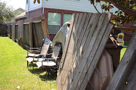
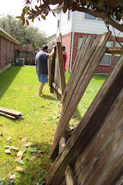
One of my biggest concerns are these wood fences we have everywhere, because those posts are going to become projectiles. Look around you home and figure out the most interior, fortified location. An interior bathroom is ideal.

People in the Sugar Land area are asking me how strong of winds could we get...with a healthy Category 3, 90 mph.

More to come!
Cecilia Sinclair
Wonder Weather Woman

Yikes...Models Curving...what I was afraid of!

All the models are showing a curve...influence from the trough. Even though the strike locations are still south of the upper Texas coast, everything is shifting back north!!! Again, there is so much error at this point...everyone watch this thing. Please stock up!

I'll have more later, but I just don't like this back and forth business. I don't want anyone caught off guard.

Ike will be in the Gulf later this evening. Here we go.

Cecilia Sinclair
Wonder Weather Woman

Most models now agree...Ike track further south

HURRICANES AND WEATHER
Well you can probably guess why I am late...trying to automate the posting of this blog. Appreciate your cooperation and patience.Feeling better about Ike but still see a few models which show an influence of the incoming trough and turn it northward. No current model runs show a direct hit for the upper Texas Coast.

Highest percentage show a King Ranch landfall late Friday, early Saturday.Please watch it though because a turn to the north could send it rapidly our way at the last minute. Let's not let our guard down.

If it moves in to our south, we should get some rain. My fall garden will appreciate that.

It should be a major hurricane at landfall...so there will be potential for damage. The King Ranch is sparsely populated although Kingsville is just to the north.

SPANISH

Since we have some rain in the forecast, thought I would do lluvia, the Spanish word for rain. This is pronounced you-vee-ah. Yep, we sure could use some you-vee-ah.

Effects of spanish immersion on children's native english vocabulary were studied. Matched on grade, sex, and verbal scores on a 4th-grade Cognitive Abilities Test (CAT), 30 th- and 6th-grade immersion students and 30 english monolinguals did 60 consecutive Peabody Picture Vocabulary Test (PPVT) items...Findings support the idea that Spanish immersion has English-language benefits and that positive transfer (cross linguistic influence) occurs from Spanish as a foreign language to native English receptive vocabulary.

This came from Cunningham, T.H., & Graham, C.R. (2000). Increasing native english vocabulary recognition through Spanish immersion: cognate transfer from foreign to first language. Journal of Education Psychology, 92(1), 378-49. from PsycINFO database.Looking for something educational and entertaining. Order my Dr. Toy Top 10 Education Product award winning DVD, Let's Learn Spanish with Frank & Paco from from http://www.frankandpaco.com, Ventura's Educational Supply, Dolo Publications, Carlex Inc., The Curious Mind Store, amazon.com, bestbuy.com, and barnesandnoble.com.

AND MORE

I am on the board of The John C. Freeman Weather Museum, the nation's first and only weather museum and it's right here in Houston, 5104 Caroline St.--the heart of the museum district. If you haven't checked it out, please do so!!! Your kids will love it!!! The museum has done so much for our community already...encouraging youngsters to pursue careers in math and science. They offer fantastic weather camps. And we have a fun Groundhog Day gala coming up on Feb. 2, 2009. You can find out more by going to http://wxresearch.org/.


That's it for now. Don't worry...I'm watching Ike for you! Have a great day and be safe!

Cecilia Sinclair
Wonder Weather Woman